New paint for the Ninjette?

I’m toying with the idea of having the Ninjette painted.

I absolutely adore the 1989 color scheme:


But y’all know me — I love red bikes.    So I asked STN to whip me up a Photoshop of the paint scheme inverted, and I really like this one too (I would have black wheel rims, though, don’t worry 🙂 ):


Hrmmmm.   The white in either case would be a shimmery pearl white (yum) and the red in either case would be a deep red, like the color of my 2001 SV650S, or probably pretty close to Kawasaki’s own Candy Persimmon Red.

Decisions, decisions!

Posted in Ninja 250 | 3 Comments

E2E Ride: Colma Cemeteries

One of the juicier photo tags for the Equinox to Equinox rally is a cemetery older than 100 years.  Each tagged cemetery is 7 points which, for those of us who only have like 100 points, is significant.

The problem for me was that I could only think of one such cemetery nearby (Union Cemetery in Redwood City).  I decided to consult the Google machine and thank goodness I did, because I learned that Colma, a mere 20 miles north of me, is a veritable gold mine of historical cemeteries.

How many cemeteries does Colma have?  The town was founded in 1924 as a necropolis.  The town motto is: “It’s great to be alive in Colma!”and it’s also known as “the city of the silent”.  The dead outnumber the living in Colma by 1000 to 1.

This happened for one simple reason:  San Francisco.  It passed an ordinance in 1900 that no new cemeteries could be built in the city and then, in 1912, SF evicted all existing cemeteries from city limits.  The dead had to go somewhere, and they went to Colma.

My day started in a livelier locale: Nini’s Coffee Shop in San Mateo.  Yum!


My first stop was also in San Mateo: St John’s Cemetery, founded in 1885.


OK, seven points in, let’s go to Colma.

First stop was the massive Cypress Lawn Memorial Park (1892).  My online list of cemeteries was in alphabetical order and since Colma isn’t very large, I mostly just hit them in order, entering the next one into the GPS as I went.    I found out after I got home that William Randolph Hearst is buried at Cypress Lawn; I wish I’d known that and searched out the grave.  Though Cypress Lawn is huge and I may never have gotten to a second cemetery in Colma if I’d tried to find it.

Also, for the most part, my photography in the cemeteries weren’t of notable graves — instead, ones I thought indicative of the general vibe of the cemetery or had something unusual.   I was surprised by the separate personalities of each location.


Next up was Woodlawn Memorial Park (1904) — out of order alphabetically, but it was right next to Cypress Lawn.

Woodlawn was the first of the cemeteries that I visited with a massive Chinese section.  I thought it was really interesting.


Woodlawn also has a pretty famous resident:


(If you don’t know about Emperor Norton, get thee to Wikipedia)

Eternal Home Cemetery (1901) was next.  This cemetery was pretty small, so the only picture I took was for the rally with my cell phone.


Next, I went to Greenlawn Memorial Park (1903).  This one really highlights how the cemeteries are everywhere in Colma; note the classy juxtaposition of the French memorial and the Best Buy.


Hills of Eternity Jewish Cemetery (1889) was the first specifically ethnic cemetery I visited.


While leaving the Hills of Eternity, I literally bumped into the next cemetery: The Serbian Cemetery (1901).   Its Chapel of the Assumption of the Virgin Mary is a replica of a 1,000 year old structure in Serbia.


Even pets have somewhere to die in Colma:


Back to our rough alphabetical order, I headed to Holy Cross Catholic Cemetery (1887).   This one has the honor of being the oldest and largest cemetery in Colma.   Joe DiMaggio is buried here, as are many local political figures (including notable San Francisco mayor George Moscone).


Home of Peace Cemetery (1889) is on the same plot as the Hills of Eternity.  My favorite part of it was this little hobbit-hole mausoleum.


My favorite cemetery was next: the Italian Cemetery (1899).  This cemetery was breathtakingly beautiful.  Not only were the graves and mausoleums aesthetically pretty, the layout of the cemetery was interesting and intricate.  The alleyways were mostly cobblestone, lending a European feel to the experience.   Like most of the cemeteries I visited, it was empty, so I didn’t feel too badly about riding around amongst the mausoleums.


Most cemeteries had a dedicated children’s section, which I generally avoided due to Mom Hormones.  The Italian Cemetery children’s section was breathtaking, though, and I parked to take a ton of photos there.  It was absolutely heartbreaking but beautiful.


I didn’t go inside the Japanese Cemetery (1901) as it was very small off the side of the road and I didn’t feel like parking and taking my gear off to walk inside.


In the Olivet Memorial Park (1896), I found proof that you just never know what you’re going to encounter on the road.  I was heading out of the cemetery when I happened to turn my head and see this, which I think is probably close to the creepiest awesome thing I have ever seen.


Finally, my Colma adventures ended at the Salem Memorial Park and Garden Mausoleum (1891).  It was originally founded in 1877 as part of San Francisco’s City Cemetery in the Ocean Beach neighborhood, but moved to Colma and became the third Jewish Cemetery there.


So that was my ride today.   If my math is correct, I got 13 cemeteries plus 1 historical marker, so 96 points total.  Hooray!  Not the longest ride, but definitely an interesting one.

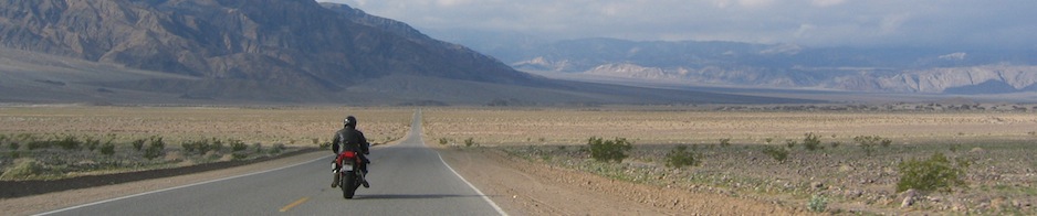
Not my usual kind of twisty road:


Posted in Ninja 250, Rides | 1 Comment

E2E Ride: San Juan Bautista

This past Tuesday, I hopped on el interstato down to the booming metropolis of San Juan Bautista.  It’s a small agricultural town of about 1800 people in San Benito County.  It has a pretty impressive historical background, which made it a good destination for an Equinox to Equinox Rally ride.

Beautiful downtown San Juan Bautista:


Who says history is boring?  This is a two-story outhouse in back of the Plaza Hotel.  Women and children used the upper hole; men the lower.


In addition to the outhouse (which I cleared with the Rally grand poombas as being acceptable as a “roadside statue/attraction”), I photographed the Mission San Juan Bautista (historical marker), Castro Adobe (historical marker), Plaza Hotel (historical marker), the town post office, and the city hall.   This will increase my score by a whopping 27 points.  Since I’m currently in like 2 millionth place, this is important.  😀


After a quick lunch at The Pizza Factory (which I believe I’ve eaten at 100% of the times I’ve stopped in San Juan Bautista),  I headed for the back roads up Fremont Peak.  My excuse was that there’s a historical marker up there — 5 more points! — but really I just wanted some nice twisty roads to interject into my day of freeways.

This brings us to the June 18 edition of “So, hey, how was your Tuesday?”:


Fremont Peak sits at 3173′ elevation and is a summit in the Gavilan Range.   It’s somewhat amusing (at least to us history buffs) that two of the historical markers in San Juan Bautista are for Castro (the adobe in town) and Fremont, given the story of the peak:

“Previously called Gavilan Peak, it is now named for John C. Frémont, an American explorer and a Captain in the U.S. Army Corps of Topographical Engineers.  In 1846, he and a crew of 60 armed surveyors mounted the peak to assess its military value. The peak commands the inland approach from Monterey. As a response to the threat, local Mexican authority General José Castro ordered Frémont and his men to leave California. In defiance, Frémont built a crude stockade and raised a modified American flag above the peak. The U.S. Consul in Monterey, Thomas Larkin, supported Castro’s decision to evict Frémont, and his men were duly ordered out of the area.”

(Citation from http://en.wikipedia.org/wiki/Fremont_Peak_(California) with some minor grammatical errors corrected)

The ride down has some pretty amazing views of Salinas Valley.


(Trivia: the above view is also the tag for the first-ever Sport-Touring.net Bay Area photo tag.)

The Hollister Hills Off-Road park and its miles of dirt trails are also very visible on the descent:


When I got back down into San Juan Bautista, I decided to take Highway 129 west over to Watsonville and then Highway 1 up to Santa Cruz instead of taking Highway 101 straight north (I’d taken 101 south that morning).  This was a wise choice; there was some traffic but not a ton, and the following view is always preferable to an eight-lane interstate:


Ride stats:


Posted in Ninja 250, Rides | Leave a comment

Skyline Blvd

Oops, I guess I didn’t do much riding last month.  I did actually take the bike on a few errands, including taking the long way home, but that didn’t make for very interesting blog fodder.

I did roll over 20k on the Ninjette, which was cool:

So, yay, there was that.

Anyway, I did go on a nice ride today, thank goodness.  I have almost no time to blog about it, so this may just end up being a photo dump, but at least it’s an update!

My plan for the day was to head to Skyline Blvd and Highway 92, which is almost as far north on Skyline as you can get these days due to road closure/construction at Crystal Springs Dam.  Then I would head south and take Skyline as far south as possible.

The area around Skyline and 92 is almost always fogged in.  That particular section of the Santa Cruz Mountains just attracts fog and moisture like nobody’s business.


It cleared up fairly quickly — within 6 or 7 miles, I’d guess — and the rest of the day was bright and sunny.


The section of Skyline between Highways 92 and 84 is pretty consistently what you see above.  Mostly long straight sections, redwood and pine trees shading the road.


Probably the most famous stop along Skyline Blvd:  Alice’s Restaurant!  I had already eaten breakfast and it wasn’t yet lunchtime, so I didn’t go inside, but I could hardly pass by without a photo.

South of Alice’s, Skyline opens up a lot.  The road passes quite a few open space preserves as it runs through the Palo Alto area, offering great views.  I managed not to get any good photos for various lame reasons (I totally spaced out and rode right past the best shoulder opportunity for vista shots), but here’s a sort of crappy one:


About 14 miles south of Alice’s is Four Corners, the intersection of Highways 9 and 35 (Skyline is also known as Highway 35).   There wasn’t much going on there this morning but this parking lot is always bustling on the weekends, between motorcyclists, hikers, bicyclists, rock climbers (for the nearby Castle Rock State Park)….


I hadn’t been on the very southern part of Skyline in a while and I had completely forgotten that it gets very narrow, very abruptly.

It goes from this:


To this:


Pretty much around one corner.  You’re tooling along around 40 or 50mph and suddenly you turn a corner and there’s like half the road there that there had been.  Brake check!

It meanders like the above for about four miles in between Black Road and Bear Creek Road, a distance that takes considerably longer than four miles of the previous section.

It does, however, offer excellent views:


A passing bicyclist took this picture of me looking like a complete dork:


Christmas trees, anyone?  This little snowman was one of the Sport-Touring.net photo tags a few years ago.  I’m pretty sure that was the last time I was on this section of Skyline.


Skyline ends at Bear Creek Road, but Highway 35 continues on as Summit Road.  I took Summit for a few miles before peeling off on Old Santa Cruz Highway for a short diversion:


This little driveway is the entrance to Hazlwood-at-the-Summit, where Peter and I were married almost exactly six years ago (June 2, 2007).   I didn’t go down the driveway as it’s a private residence and there were people out and about, but it was nice to pay a short visit.

Happy anniversary, sweetie! 🙂


After saying hello to Hazlwood, I retraced my route back to Summit Road and headed south to the Summit Store for lunch.   Yum yum!  I ate outside under the porch umbrellas and was thoroughly happy.


I decided that lunch at the Summit Store was a good southern terminus for my Highway 35 adventuring, so I took Soquel-San Jose Road south to Laurel Glen Road west to Mountain View Road west to Vine Hill road north up to Highway 17.  They were nice roads but fairly uneventful.

I was tailgated for a while on Soquel-San Jose by some jerk who wound up passing me on the double yellow while I was going 10mph over the speed limit…whatever, dude (note that there were no turnouts or driveways, otherwise I would have moved for him.  He just didn’t want to wait for me to find a safe place to pull over).

I took the freeway most of the way home, blah blah boring.

Ride stats:

Posted in Ninja 250, Rides | 1 Comment

Kira’s first motorcycle

Sweet baby jesus with a chainsaw, this has been slow and basically unreadable lately.    We’re trying to work it out with our web hosting provider (since it’s not just this blog but all of the eleventy million sites that Peter and I collectively run for work/family/fun).  I think we’ve been escalated a dozen times and I’m not sure when it’s going to be fixed. 🙁

In the meantime, have adorable photos of Kira’s first motorcycle.   She rides like I do — she scoots her butt way over in the seat, puts her left foot down, and dangles her right foot way up in space.  I reassure her that she doesn’t need to flatfoot, but she does need to pay a bit more attention to how she parks.  Right now her dismount method is to just stop and let the bike fall over…which, granted, was more or less how I rode the SV650S.

We took our first long sport-touring ride yesterday: from the playroom into the kitchen and almost fully around the kitchen island.   She got bored near the kitchen table, though, and dropped the bike (sorry, she “had to lay it down”) to go over and inspect the cat dish.  Ride to eat; eat to ride!


Posted in Administrivia, Kira, The Daily Grind | Leave a comment